
קובץ:LINE21.jpg
גודל התצוגה המקדימה הזאת: 800 × 552 פיקסלים. רזולוציות אחרות: 320 × 221 פיקסלים | 640 × 442 פיקסלים | 1,000 × 690 פיקסלים.
לקובץ המקורי (1,000 × 690 פיקסלים, גודל הקובץ: 102 ק"ב, סוג MIME: image/jpeg)
| זהו קובץ שמקורו במיזם ויקישיתוף. תיאורו בדף תיאור הקובץ המקורי (בעברית) מוצג למטה. |
תקציר
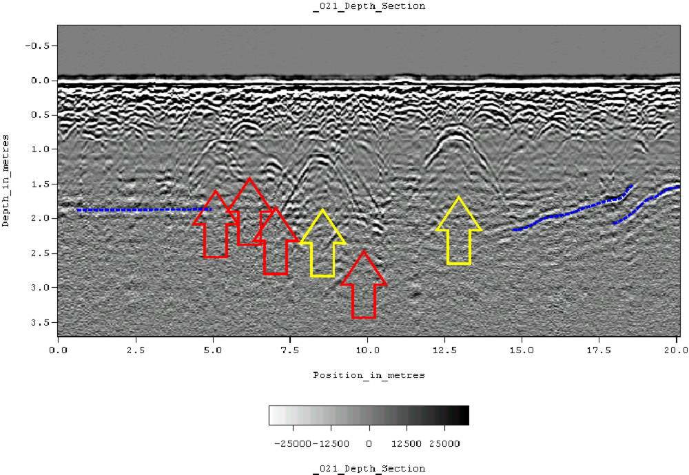
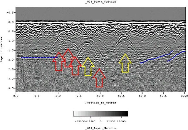
| תיאור | Ground-penetrating radar depth section (profile) collected on an historic cemetery in Alabama, USA. Yellow arrows indicate very distinct reflections, probably associated with human burials. "hyperbolic" reflections, appearing as an inverted U, are typically associated with discrete objects. Less distinct hyperbolic reflections are indicated by red arrows. dashed blue lines indicate horizontal and sloping reflectors, probably bedrock. The many smaller reflections near the surface are likely to be caused by tree roots. Because of the nature of the site, subsurface testing was not conducted, but these interpretations are supported by surface indications (grave markers and depressions) and with line-to-line patterning within the GPR data. |
| תאריך יצירה | 11 ביוני 2007 (תאריך העלאה מקורי) |
| מקור | הועבר מ- en.wikipedia לוויקישיתוף. |
| יוצר | Tapatio מוויקיפדיה האנגלית |
רישיון
| היצירה הזאת שוחררה לנחלת הכלל על־ידי היוצר שלה, Tapatio מוויקיפדיה האנגלית. זה תקף בכל העולם. יש מדינות שבהן הדבר אינו אפשרי על פי חוק, אם כך: Tapatio מעניק לכל אחד את הזכות להשתמש ביצירה הזאת לכל מטרה, ללא שום תנאי, אלא אם כן תנאים כאלה נדרשים לפי החוק. |
יומן העלאה מקורי
תיאור הקובץ המקורי נמצא כאן. כל שמות המשתמשים הבאים מתייחסים ל-en.wikipedia.
- 2007-06-11 05:16 Tapatio 1000×690×8 (104839 bytes) {{PD-self}}
- 2007-06-11 04:49 Tapatio 1000×690×8 (104839 bytes) Ground-penetrating radar depth section (profile) collected on an historic cemetery in Alabama, USA. Yellow arrows indicate very distinct reflections, probably associated with human burials. "Parabolic" reflections, appearing as an inverted U, are typicall
היסטוריית הקובץ
ניתן ללחוץ על תאריך/שעה כדי לראות את הקובץ כפי שנראה באותו זמן.
| תאריך/שעה | תמונה ממוזערת | ממדים | משתמש | הערה | |
|---|---|---|---|---|---|
| נוכחית | 22:02, 17 באוקטובר 2007 | | 690 × 1,000 (102 ק"ב) | Conscious | full resolution |
| 22:22, 2 באוקטובר 2007 |  | 552 × 800 (105 ק"ב) | Rosarinagazo | Ground-penetrating radar depth section (profile) collected on an historic cemetery in Alabama, USA. Yellow arrows indicate very distinct reflections, probably associated with human burials. "hyperbolic" reflections, appearing as an inverted U, are typical |
שימוש בקובץ
הדף הבא משתמש בקובץ הזה:
שימוש גלובלי בקובץ
אתרי הוויקי השונים הבאים משתמשים בקובץ זה:
- שימוש באתר ar.wikipedia.org
- שימוש באתר ca.wikipedia.org
- שימוש באתר da.wikipedia.org
- שימוש באתר de.wikipedia.org
- שימוש באתר el.wikipedia.org
- שימוש באתר en.wikipedia.org
- שימוש באתר es.wikipedia.org
- שימוש באתר et.wikipedia.org
- שימוש באתר fr.wikipedia.org
- שימוש באתר ml.wikipedia.org
- שימוש באתר nl.wikipedia.org
- שימוש באתר nn.wikipedia.org
- שימוש באתר no.wikipedia.org
- שימוש באתר pl.wikipedia.org
- שימוש באתר pt.wikipedia.org
- שימוש באתר sk.wikipedia.org
- שימוש באתר vi.wikipedia.org
- שימוש באתר zh.wikipedia.org