
קובץ:Lake Tiberias (Sea of Galilee), Northern Israel.jpg
גודל התצוגה המקדימה הזאת: 398 × 599 פיקסלים. רזולוציות אחרות: 159 × 240 פיקסלים | 319 × 480 פיקסלים | 510 × 768 פיקסלים | 680 × 1,024 פיקסלים | 1,440 × 2,168 פיקסלים.
לקובץ המקורי (1,440 × 2,168 פיקסלים, גודל הקובץ: 1.15 מ"ב, סוג MIME: image/jpeg)
| זהו קובץ שמקורו במיזם ויקישיתוף. תיאורו בדף תיאור הקובץ המקורי (בעברית) מוצג למטה. |
,_Northern_Israel.jpg)
,_Northern_Israel.jpg?uselang=he)
תקציר
| תיאור |
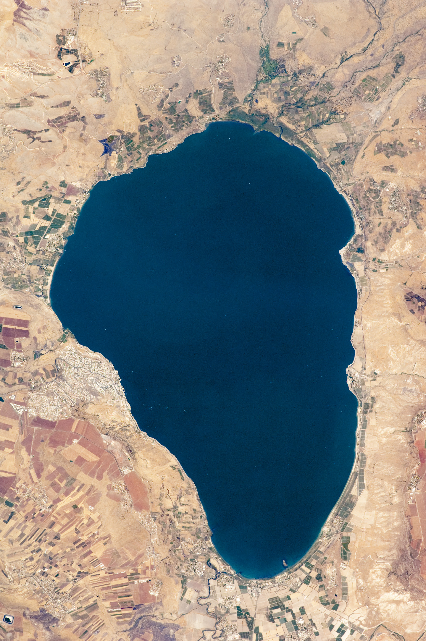
English: Israel’s largest freshwater lake, Lake Tiberias, is also known as the Sea of Tiberias, Lake of Gennesaret, Lake Kinneret, and the Sea of Galilee. The lake measures just more than 21 kilometres north-south, and it is only 43 meters deep. The lake is fed partly by underground springs related to the Jordan sector of the Great Rift Valley, but most of its water comes from the Jordan River, which enters from the north. The river’s winding course can be seen draining the south end of the lake at image bottom. Angular green and brown field patterns clothe most hillsides in this arid landscape. Bright roof tops are the hallmark of several villages in the area. The largest grouping of bright roofs and city blocks indicates the location of Tiberias (named for the Roman Emperor Tiberius), visible at image left on the south-western shore of the lake.
|
||||||||||||||||||||||||||||||||||||||||||||||||||
| תאריך יצירה | |||||||||||||||||||||||||||||||||||||||||||||||||||
| מקור | NASA Earth Observatory | ||||||||||||||||||||||||||||||||||||||||||||||||||
| יוצר | This image was taken by the NASA Expedition 20 crew. | ||||||||||||||||||||||||||||||||||||||||||||||||||
| גרסאות אחרות | Derivative works of this file: (Sea of Galilee Northern Israel-2.jpg | ||||||||||||||||||||||||||||||||||||||||||||||||||
Image acquired with a Nikon D2Xs digital camera fitted with an 400 mm lens, and is provided by the ISS Crew Earth Observations experiment and Image Science & Analysis Laboratory, Johnson Space Centre.
רישיון
| קובץ זה נמצא ברשות הציבור מכיוון שהוא נוצר על ידי נאס"א. מדיניות זכויות היוצרים של נאס"א קובעת ש"חומרים של NASA אינם מוגנים בזכויות יוצרים אלא אם צוין אחרת". (דף מדיניות זכויות היוצרים ב-NASA או מדיניות שימוש בתמונות ב-JPL). | ||
 |
אזהרות:
|
היסטוריית הקובץ
ניתן ללחוץ על תאריך/שעה כדי לראות את הקובץ כפי שנראה באותו זמן.
| תאריך/שעה | תמונה ממוזערת | ממדים | משתמש | הערה | |
|---|---|---|---|---|---|
| נוכחית | 14:32, 14 בספטמבר 2009 | | 2,168 × 1,440 (1.15 מ"ב) | Originalwana | {{Information |Description={{en|1=Israel’s largest freshwater lake, Lake Tiberias, is also known as the Sea of Tiberias, Lake of Gennesaret, Lake Kinneret, and the Sea of Galilee. The lake measures just more than 21 kilometres north-south, and it is |
שימוש בקובץ
הדפים הבאים משתמשים בקובץ הזה:
- ויקיפדיה:ערכים מומלצים/המלצות קודמות/יולי 2013
- ויקיפדיה:ערכים מומלצים/המלצות קודמות/פברואר 2018
- ויקיפדיה:תמונה מומלצת/הוספה למומלצים/ארכיון 40
- ויקיפדיה:תמונה מומלצת/המלצות קודמות/יולי 2012
- תבנית:ערך מומלץ 11 בפברואר 2018
- תבנית:ערך מומלץ 12 בפברואר 2018
- תבנית:ערך מומלץ 1 ביולי 2013
- תבנית:ערך מומלץ 2 ביולי 2013
- תבנית:תמונה מומלצת 23 ביולי 2012
- פורטל:ערכים מומלצים/ערכים/הכנרת
שימוש גלובלי בקובץ
אתרי הוויקי השונים הבאים משתמשים בקובץ זה:
- שימוש באתר af.wikipedia.org
- שימוש באתר ar.wikipedia.org
- שימוש באתר bn.wikipedia.org
- שימוש באתר br.wikipedia.org
- שימוש באתר ceb.wikipedia.org
- שימוש באתר cy.wikipedia.org
- שימוש באתר de.wikipedia.org
- שימוש באתר el.wikipedia.org
- שימוש באתר en.wikipedia.org
- שימוש באתר en.wikivoyage.org
- שימוש באתר eo.wikipedia.org
- שימוש באתר es.wikipedia.org
- שימוש באתר eu.wikipedia.org
- שימוש באתר fy.wikipedia.org
- שימוש באתר ga.wikipedia.org
- שימוש באתר he.wikivoyage.org
- שימוש באתר hy.wikipedia.org
- שימוש באתר ia.wikipedia.org
- שימוש באתר id.wikipedia.org
- Danau Superior
- Danau Titicaca
- Danau Pedu
- Danau Victoria
- Danau Sidihoni
- Danau Inari
- Danau Nikaragua
- Danau Thun
- Danau Como
- Cekungan endoreik
- Danau Michigan
- Danau Huron
- Danau Erie
- Danau Ontario
- Danau Yamanaka
- Danau Kawaguchi
- Danau Saiko
- Danau Shōji
- Danau Motosu
- Danau Garam Besar
- Daftar kumpulan danau-danau besar (Afrika)
- Danau Vättern
- Danau Galilea
- Danau Khaiyr
- Danau Chini
,_Northern_Israel.jpg)
,_Northern_Israel.jpg)