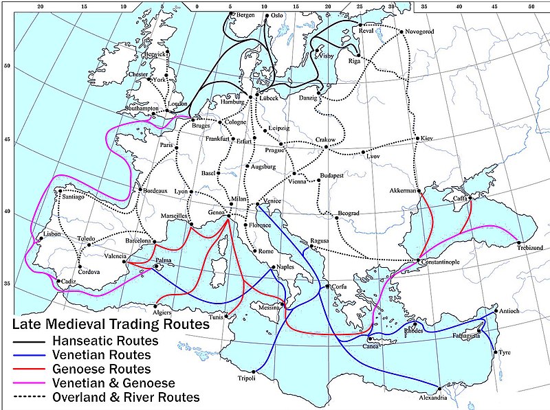
קובץ:Late Medieval Trade Routes.jpg

גודל התצוגה המקדימה הזאת: 800 × 597 פיקסלים. רזולוציות אחרות: 320 × 239 פיקסלים | 640 × 478 פיקסלים | 1,024 × 765 פיקסלים | 1,280 × 956 פיקסלים | 1,457 × 1,088 פיקסלים.
לקובץ המקורי (1,457 × 1,088 פיקסלים, גודל הקובץ: 372 ק"ב, סוג MIME: image/jpeg)
היסטוריית הקובץ
ניתן ללחוץ על תאריך/שעה כדי לראות את הקובץ כפי שנראה באותו זמן.
| תאריך/שעה | תמונה ממוזערת | ממדים | משתמש | הערה | |
|---|---|---|---|---|---|
| נוכחית | 23:46, 18 במאי 2022 |  | 1,088 × 1,457 (372 ק"ב) | Richard2s | Clearer key for map |
| 23:25, 23 בינואר 2011 |  | 544 × 853 (453 ק"ב) | Micsha~commonswiki | Includes map key on the map | |
| 18:55, 28 במרץ 2008 |  | 1,120 × 1,817 (487 ק"ב) | Lampman | {{Information |Description=Map showing the main trade routes of late medieval Europe. The black lines show the routes of the Hanseatic League, the blue Venetian and the red Genoese routes. Purple lines are routes used by both the Venetians and the Genoese |
שימוש בקובץ
הדפים הבאים משתמשים בקובץ הזה:
שימוש גלובלי בקובץ
אתרי הוויקי השונים הבאים משתמשים בקובץ זה:
- שימוש באתר ar.wikipedia.org
- שימוש באתר be-tarask.wikipedia.org
- שימוש באתר bg.wikipedia.org
- שימוש באתר ca.wikipedia.org
- שימוש באתר da.wikipedia.org
- שימוש באתר el.wikipedia.org
- שימוש באתר en.wikipedia.org
- שימוש באתר es.wikipedia.org
- שימוש באתר et.wikipedia.org
- שימוש באתר fr.wikipedia.org
- שימוש באתר hy.wikipedia.org
- שימוש באתר it.wikipedia.org
- שימוש באתר ja.wikipedia.org
- שימוש באתר mk.wikipedia.org
- שימוש באתר nl.wikipedia.org
- שימוש באתר pl.wikipedia.org
- שימוש באתר pt.wikipedia.org
- שימוש באתר rm.wikipedia.org
- שימוש באתר sh.wikipedia.org
- שימוש באתר sl.wikipedia.org
- שימוש באתר sq.wikipedia.org
- שימוש באתר uk.wikipedia.org
- שימוש באתר vi.wikipedia.org
- שימוש באתר www.wikidata.org


