
קובץ:Potomacwatershedmap.png
גודל התצוגה המקדימה הזאת: 800 × 545 פיקסלים. רזולוציות אחרות: 320 × 218 פיקסלים | 640 × 436 פיקסלים | 1,024 × 698 פיקסלים | 1,467 × 1,000 פיקסלים.
לקובץ המקורי (1,467 × 1,000 פיקסלים, גודל הקובץ: 1.41 מ"ב, סוג MIME: image/png)
| זהו קובץ שמקורו במיזם ויקישיתוף. תיאורו בדף תיאור הקובץ המקורי (בעברית) מוצג למטה. |
תקציר
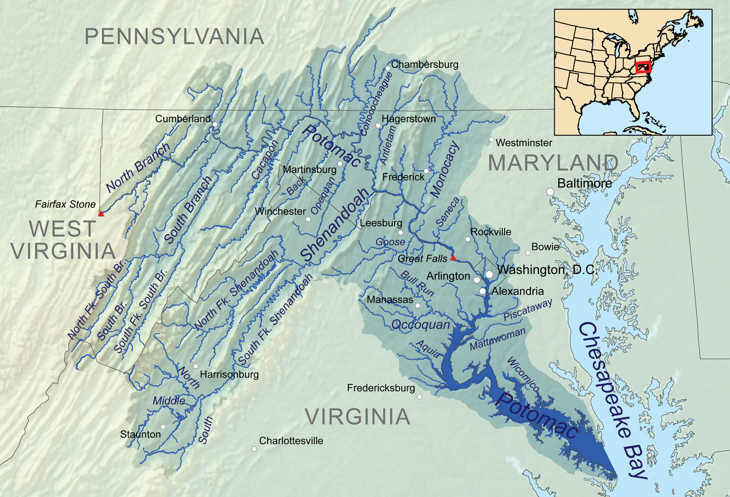
| תיאור | Map showing the Potomac River drainage basin. |
| תאריך יצירה | |
| מקור | נוצר על־ידי מעלה היצירה, Elevation data from SRTM, hydrologic data from the National Hydrography Dataset, urban areas from Vector Map, all other features from the National Atlas. |
| יוצר | Kmusser |
| גרסאות אחרות | File:Potomac watershed.png |
רישיון
אני, בעל זכויות היוצרים על עבודה זו, מפרסם בזאת את העבודה תחת הרישיון הבא:
הקובץ הזה מתפרסם לפי תנאי רישיון קריאייטיב קומונז ייחוס-שיתוף זהה 3.0 לא מותאם.
- הנכם רשאים:
- לשתף – להעתיק, להפיץ ולהעביר את העבודה
- לערבב בין עבודות – להתאים את העבודה
- תחת התנאים הבאים:
- ייחוס – יש לתת ייחוס הולם, לתת קישור לרישיון, ולציין אם נעשו שינויים. אפשר לעשות את זה בכל צורה סבירה, אבל לא בשום צורה שמשתמע ממנה שמעניק הרישיון תומך בך או בשימוש שלך.
- שיתוף זהה – אם תיצרו רמיקס, תשנו, או תבנו על החומר, חובה עליכם להפיץ את התרומות שלך לפי תנאי רישיון זהה או תואם למקור.
היסטוריית הקובץ
ניתן ללחוץ על תאריך/שעה כדי לראות את הקובץ כפי שנראה באותו זמן.
| תאריך/שעה | תמונה ממוזערת | ממדים | משתמש | הערה | |
|---|---|---|---|---|---|
| נוכחית | 03:10, 4 בינואר 2011 | | 1,000 × 1,467 (1.41 מ"ב) | Kmusser | == Summary == {{Information |Description=Map showing the Potomac River drainage basin. |Source={{own}}, Elevation data from SRTM, hydrologic data from the [[:w:National Hydrography Dataset|Natio |
שימוש בקובץ
הדף הבא משתמש בקובץ הזה:
שימוש גלובלי בקובץ
אתרי הוויקי השונים הבאים משתמשים בקובץ זה:
- שימוש באתר ar.wikipedia.org
- שימוש באתר ast.wikipedia.org
- שימוש באתר azb.wikipedia.org
- שימוש באתר br.wikipedia.org
- שימוש באתר cs.wikipedia.org
- שימוש באתר de.wikipedia.org
- שימוש באתר en.wikipedia.org
- שימוש באתר eo.wikipedia.org
- שימוש באתר es.wikipedia.org
- Maryland
- Baltimore
- Cumberland (Maryland)
- Bowie (Maryland)
- Westminster (Maryland)
- Frederick (Maryland)
- Hagerstown (Maryland)
- Río Potomac
- Charlottesville
- Condado de Arlington
- Alexandria (Virginia)
- Harrisonburg
- Winchester (Virginia)
- Fredericksburg (Virginia)
- Staunton (Virginia)
- Manassas (Virginia)
- Chambersburg
- Leesburg (Virginia)
- Great Falls (Virginia)
- Martinsburg (Virginia Occidental)
- Washington D. C.
- Río Shenandoah
- שימוש באתר fi.wikipedia.org
- שימוש באתר fr.wikipedia.org
- שימוש באתר hu.wikipedia.org
- שימוש באתר io.wikipedia.org
- שימוש באתר la.wikipedia.org
- שימוש באתר lv.wikipedia.org
- שימוש באתר pms.wikipedia.org
- שימוש באתר pnb.wikipedia.org
- שימוש באתר pt.wikipedia.org
- שימוש באתר sh.wikipedia.org
- שימוש באתר sr.wikipedia.org
- שימוש באתר sv.wikipedia.org
- שימוש באתר ta.wikipedia.org
- שימוש באתר th.wikipedia.org