
קובץ:CONTEXTUAL VIEW OF BRIDGE IN SETTING, LOOKING NORTHEAST, FROM UPSTREAM - Smith River Bridge, CA State Highway 199 Spanning Smith River, Crescent City, Del Norte County, CA HAER CAL,8-CRECI.V,1-2.tif

גודל התצוגה המקדימה הזאת מסוג JPG של קובץ ה־TIF הזה: 750 × 599 פיקסלים. רזולוציות אחרות: 300 × 240 פיקסלים | 601 × 480 פיקסלים | 961 × 768 פיקסלים | 1,280 × 1,023 פיקסלים | 2,560 × 2,046 פיקסלים | 4,632 × 3,702 פיקסלים.
לקובץ המקורי (4,632 × 3,702 פיקסלים, גודל הקובץ: 16.36 מ"ב, סוג MIME: image/tiff)
| זהו קובץ שמקורו במיזם ויקישיתוף. תיאורו בדף תיאור הקובץ המקורי (בעברית) מוצג למטה. |
תקציר
| CONTEXTUAL VIEW OF BRIDGE IN SETTING, LOOKING NORTHEAST, FROM UPSTREAM - Smith River Bridge, CA State Highway 199 Spanning Smith River, Crescent City, Del Norte County, CA | ||||
|---|---|---|---|---|
| צלם |
Tateishi, Don Related names:
|
|||
| כותרת |
CONTEXTUAL VIEW OF BRIDGE IN SETTING, LOOKING NORTHEAST, FROM UPSTREAM - Smith River Bridge, CA State Highway 199 Spanning Smith River, Crescent City, Del Norte County, CA |
|||
| המקום המוצג | California; Del Norte County; Crescent City | |||
| תאריך יצירה | 1989 | |||
| ממדים | 4 x 5 in. | |||
| מיקום נוכחי |
Library of Congress Prints and Photographs Division Washington, D.C. 20540 USA http://hdl.loc.gov/loc.pnp/pp.print |
|||
| מספר גישה |
HAER CAL,8-CRECI.V,1-2 |
|||
| ייחוס |
|
|||
| הערות |
|
|||
| מקור | https://www.loc.gov/pictures/item/ca1545.photos.020447p | |||
| אישורים והיתרים (שימוש חוזר בקובץ זה) |
|
|||

| מיקום האובייקט | | תמונה זו ותמונות נוספות במיקום: OpenStreetMap |
|---|
היסטוריית הקובץ
ניתן ללחוץ על תאריך/שעה כדי לראות את הקובץ כפי שנראה באותו זמן.
| תאריך/שעה | תמונה ממוזערת | ממדים | משתמש | הערה | |
|---|---|---|---|---|---|
| נוכחית | 22:15, 3 ביולי 2014 | 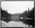 | 3,702 × 4,632 (16.36 מ"ב) | Fæ | GWToolset: Creating mediafile for Fæ. HABS batch upload 2 July 2014 (301:400) |
שימוש בקובץ
הדף הבא משתמש בקובץ הזה:
שימוש גלובלי בקובץ
אתרי הוויקי השונים הבאים משתמשים בקובץ זה:
- שימוש באתר en.wikipedia.org